Estimating COVID-19 across Parliamentary Constituencies and districts in India could facilitate better, evidence-based policy decisions

Map of India geopolitical units with title of working paper

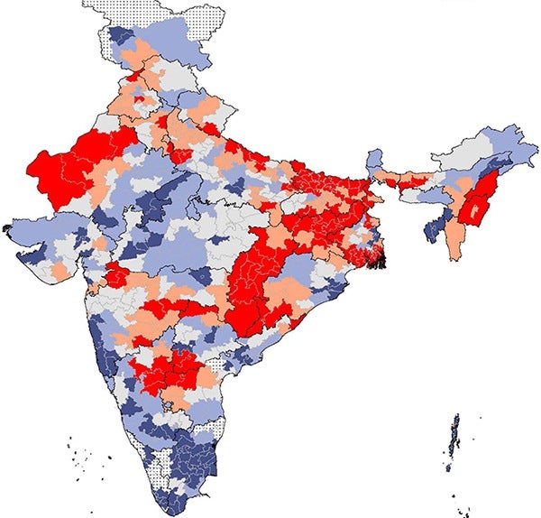
This Harvard Pop Center Working Paper presents the first estimates of COVID-19 cumulative cases and deaths per 100,000 population, and the case fatality rate (CFR) from January 7 – October 18, 2020 across 543 geopolitical units (Parliamentary Constituencies) and 721 districts of India.

Geo-mapping risk of COVID-19 in India

Map of India with PC districts in background with headline Geo-mapping of COVID-19 Risk Correlates Across Districts and Parliamentary Constituencies

A paper published in a special edition of the Harvard Data Science Review utilizes geo-mapping to identify high-risk areas for the spread of COVID-19 across the Districts and Parliamentary Constituencies of India. The researchers focus on four risk correlates including: population density percentage of population that is exposed to crowding in a household, percentage of population without access to handwashing facilities percentage of population over 65 years of age These…

For policy change in India, it really may take a village

Head shot of Subu and Rockli

Researchers at the Harvard Center for Population and Development Studies (HCPDS) have been awarded a 2.2 million dollar grant by The Bill & Melinda Gates Foundation. Harvard T.H. Chan School of Public Health professor of population health and geography and HCPDS faculty member S (Subu) V Subramanian, PhD, and HCPDS research associate Rockli Kim, ScD, are principal investigators (PIs) on the three-year project that aims to provide public policy makers…