The Public Health Disparities Geocoding Project Monograph has recently released a COVID-19 Resources page in response to the ongoing coronavirus pandemic. Dr. Jarvis T. Chen, Pamela D. Waterman, and Dr. Nancy Krieger have been using the methods of the Public Health Disparities Geocoding Project to document inequities in the population distribution of COVID-19 cases, hospitalizations, and deaths in the United States:
Using the Methods of the Public Health Disparities Geocoding Project to Monitor COVID-19 Inequities and Guide Action for Health Justice
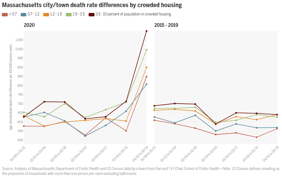
Our Public Health Disparities Geocoding Project website is newly updated to include new resources for COVID-19 analyses (& analyses of any other health outcomes) in relation to methods, codes, and data that we make freely available for work involving county, ZIP Code (ZCTA), and census tract social & economic variables – with the data provided for the entire US – along with freely available conceptual & empirical papers that inform & are informed by the methods we use.
The website is: https://www.hsph.harvard.edu/thegeocodingproject/covid-19-resources/
About The Public Health Disparities Geocoding Project Monograph
Under the leadership of Dr. Nancy Krieger, The Public Health Disparities Geocoding Project was launched to ascertain which area-based socioeconomic measures (ABSM), at which geographic level (census block group, census tract, or ZIP Code), would be suitable for monitoring US socioeconomic inequalities in the health. Drawing on 1990 census data and public health surveillance systems of 2 New England states, Massachusetts and Rhode Island, the Project analyzed data for: (a) 7 types of outcomes: mortality (all cause and cause-specific), cancer incidence (all-sites and site-specific), low birth weight, childhood lead poisoning, sexually transmitted infections, tuberculosis, and non-fatal weapons-related injuries, and (b) 18 different ABSMs. The Project conducted these analyses for both the total population and diverse racial/ethnic-gender groups, at all 3 geographic levels.
Learn more about The Public Health Disparities Geocoding Project.


