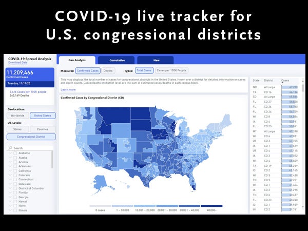
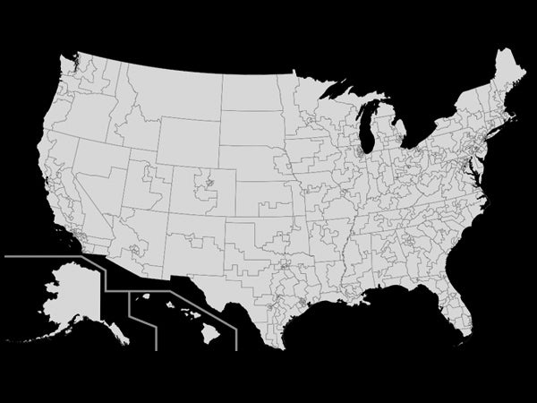
The Geographic Insights Lab is an initiative committed to improving public policies by honing in on targeted geopolitical units (such as congressional districts in the U.S. and parliamentary constituencies in India) in order to mine more precise population health and development data. This Lab, led by S V Subramanian, professor of population health and geography at Harvard T.H. Chan School of Public Health, has launched a new project that provides…
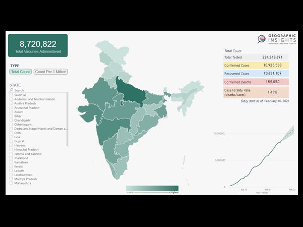
Interdisciplinary research lab release first COVID-19 live tracker for U.S. congressional districts
Researchers at the Harvard Center for Population and Development Studies, Harvard Center for Geographic Analysis at the Institute for Quantitative Social Science, and Microsoft AI for Health have joined forces to create a COVID-19 live tracker that monitors the current status of COVID-19 cases and deaths, as well as the reduction of new cases in U.S. congressional districts. Geographic Insights is an interdisciplinary research lab that is the first to…
Estimating COVID-19 across Parliamentary Constituencies and districts in India could facilitate better, evidence-based policy decisions
This Harvard Pop Center Working Paper presents the first estimates of COVID-19 cumulative cases and deaths per 100,000 population, and the case fatality rate (CFR) from January 7 – October 18, 2020 across 543 geopolitical units (Parliamentary Constituencies) and 721 districts of India.
Dashboard makes available to the public key COVID-19 metrics by U.S. congressional district
Having access to COVID-19 data for U.S. congressional districts can substantially enhance the ability of elected officials and their constituents to develop and monitor testing and vaccine deployment strategies, as well as to implement other measures to help their districts open safely. Harvard Pop Center faculty affiliate S (Subu) V Subramanian, and Research Associate Weixing Zhang are members of the team that have now made this data available to the…
Geo-mapping risk of COVID-19 in India
A paper published in a special edition of the Harvard Data Science Review utilizes geo-mapping to identify high-risk areas for the spread of COVID-19 across the Districts and Parliamentary Constituencies of India. The researchers focus on four risk correlates including: population density percentage of population that is exposed to crowding in a household, percentage of population without access to handwashing facilities percentage of population over 65 years of age These…
COVID-19 statistics by Congressional districts across the United States
Professor of population health and geography S (Subu) V Subramanian, PhD, and his colleague Priyanka N deSouza have published a paper that presents the first estimates of COVID-19 cumulative cases, deaths and case fatality rates across the 436 policy-relevant Congressional districts in the U.S. Image: Wikimediacommons
Children living on edge of malnutrition in India at greater risk of “food shocks” during national lockdowns to curb COVID-19
With one out of two children in India suffering from one form of malnutrition, there are many more who are hovering just above that threshold. The findings of this paper published in the Journal of Global Health Science estimate that even a slight shock to body weight could result in a significant uptick in cases of underweight and wasting. Study authors Sunil Rajpal, William Joe, and S V Subramanian make…
Weighing the value of crowdsourced versus official COVID-19 data in India
A piece on natureindia.com written by researchers affiliated with the Harvard Pop Center — Weixing Zhang, Rockli Kim and S V Subramanian— highlights the importance of timely data on COVID-19 infection rates in order to slow the spread of the virus. Crowdsourced data, although not verified by the Indian Council of Medical Research (ICMR), has the advantage when it comes to speed, as it may be available up to two…
Continue reading “Weighing the value of crowdsourced versus official COVID-19 data in India”
Narrowing in on disparities in life expectancy across the U.S. with help of census-tract level data
A study published in PNAS is the first to look at life-expectancy data at the local, state, and county levels across the U.S. Findings reveal significant disparities at the micro level (census-tract) suggesting that analyzing life expectancy data at the typical state and county levels may not be local enough to get an accurate picture of life expectancy inequalities. “There is a need for greater precision and targeting of local…
For policy change in India, it really may take a village
Researchers at the Harvard Center for Population and Development Studies (HCPDS) have been awarded a 2.2 million dollar grant by The Bill & Melinda Gates Foundation. Harvard T.H. Chan School of Public Health professor of population health and geography and HCPDS faculty member S (Subu) V Subramanian, PhD, and HCPDS research associate Rockli Kim, ScD, are principal investigators (PIs) on the three-year project that aims to provide public policy makers…
Continue reading “For policy change in India, it really may take a village”